- Update 3.5.3 2019/10/29
! Sometimes GeoSetter crashed when checking changed languages, for example after startup
- Update 3.5.2 2019/10/24
! Requesting location data from GeoNames didn’t work correctly with special characters, for example German umlauts
- A Minor Update after a Long Time 2019/10/20
An update to version 3.5.1 after more than one year. Unfortunately only a tiny update. Due to a long illness the work on GeoSetter is now almost 1 1/2 years behind. In the meantime, Google unfortunately changed the business model regarding the use of the Google Maps API. Unfortunately this leads to a darkened map and the hints “For development purposes only”. The reason for this is that I unfortunately had to drastically reduce the daily access of the users to the map via my Google key. Google’s first monthly bill was just under 500 Euros, which has fortunately settled down to between 50 and 100 Euros per month in the last few months due to my limitation. I would like to take this occasion to thank all users who have given me financial appreciation during this time!! 🙂 ❤ By the way, the map works, it just looks stupid…
I will now change the map to another JavaScript library, so that the mentioned restrictions will be removed. In my current estimation, this should also remove the limitation to Internet Explorer 10, so that it would probably be possible to use it under Windows XP, for example. GeoSetter would then probably be more open for many possibilities, e.g. the use of a locally installed map service, so GeoSetter could be used offline, for example. I ask for your understanding that apart from this change regarding the map connection, I will not do any changes in version 3 except for some really serious problems. As already mentioned here 1 1/2 years ago, I will resume work on version 4 instead. I don’t make any forecasts regarding a release date anymore, that was a bit of a problem last year 😀
- Update 3.5.1 2019/10/20
! After moving my webspace to a new provider, checking available updates didn’t work anymore. It will be done now by using a secure SSL connetion.
- Update 3.5 2018/05/10
Since 2011 there was no regular release of GeoSetter anymore. But there always was a beta version, on which I sometimes did some fixings or minor changes. Now I changed this version to the new regular release 3.5. It doesn’t contain any big changes or new functionality. This will come later with a major update (see also New Website, new GeoSetter Version?).
One improvement to the former version 3.4.16 is now the support for Google’s requirements regarding the version of Internet Explorer. Additionally there were problems with image files from iOS 11 devices in the last weeks, which have been read in very very slowly. This is also fixed now. Furthermore there are a lot of minor changes and fixes which I did during the last years. I will not list them all here now.
Please note: I removed the functionality for synchronizing metadata between files and folders because of some problems. As far as I know not so much users will miss that – I hope.
By the way, please see my post regarding the requirements for installed Internet Explorer here: GeoSetter and Internet Explorer
- Udpate 3.4.14 2011/01/30
* Height of dialog for editing meta data (Ctrl+E) is now changeable
* Updated help file (many thanks to Heiko Leupolz)
! Problem with loading updated translation files - Update 3.4.12 2011/01/23
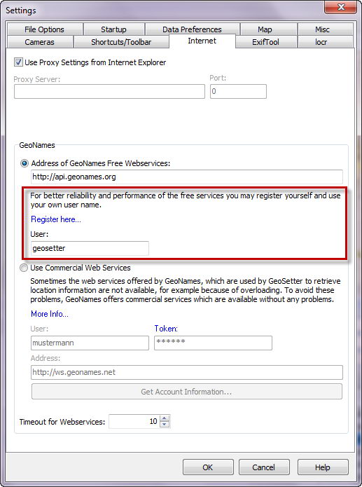
+ Using new public GeoNames server and adjustable user name. Registering for your own user account is highly recommended! See also this post in GeoNames forum
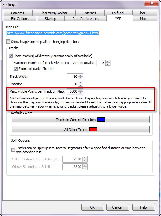
+ Maximun visible track points on map adjustable in program settings
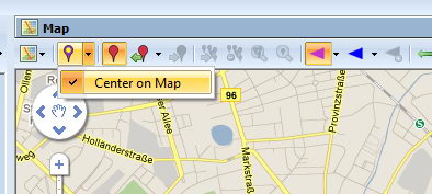
* Follow and center focused image file on map
! History of map views did not work correctly (toolbar on top of map)
! Synchronizing with GPS track files sometimes produced wrong results when using more than one track fileSome other small changes, improvements and fixes

Maximum visible track points on map 
Username for free GeoNames web services 
Follow and center focused image file on map - Update 3.4.9 2011/01/16
+ Release version will now also check for beta versions (optional)
* Updated help file (many thanks to Heiko Leupolz)
* Updated translations for Spanish and Japanese (many thanks to Santiago Del Brío and Atsushi Murai)
! Deleting images was not possible
! Explorer context menu icon appears in wrong column on Windows XP
! IPTC Source/Description URL hasn’t been saved to XMP data
! ExifTool info panel forgets collapse states and column sizeSome other small changes on user interface
- Update 3.4.2 2011/01/12
! Sometimes doing ratings by keyboard does not work
! Sometimes map crashed on application terminate - Update 3.4.0 2011/01/09
+ New designed interface and functionalety for synchronizing meta data between image files
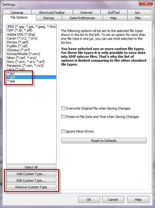
+ Support for custom file types
+ Support for compass information of Mikrokopter track files
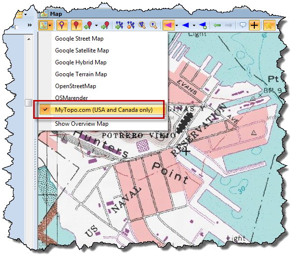
+ New map type MyTopo
+ Quick access to adjust thumbnail sizes and visible lines of meta data in thumbnail view
* Improved ExifTool info panel (Ctrl+I)
! Sometimes saved wrong UTF8 flag for IPTC data in combination with creation date
! Wrong reading of Microsoft rating tag from XMP data
! Missing preview of Pentax K-5 RAW files
! Explorer context menu did not work under Windows 7
! Timezone have been ignored in GPX track files
! Wrong coding of international characters in Google Earth exportSome other small changes, improvements and fixes

Quick Access to Adjust Thumbnail Size and Visible Lines of Meta Data 
Map Type MyTopo (only USA and Canada) 

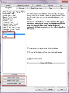
Support for Custom File Types 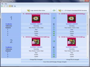
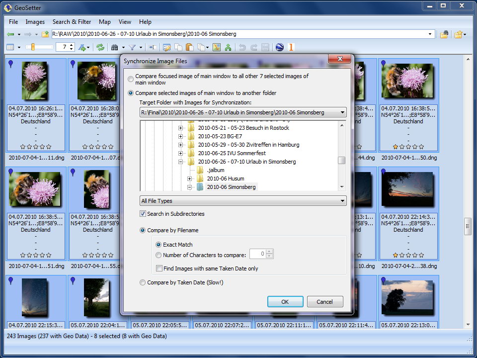
Meta Data Synchronization 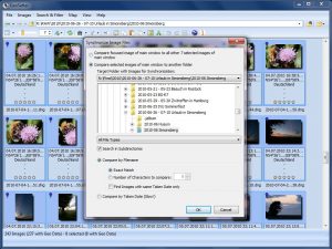
Folder and File Options for Meta Data Synchronization - Update 3.3.60 2010/07/20
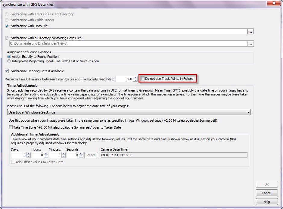
+ Optional synchronizing of heading data when synchronizing with GPS track files.
! After saving of creator data (Byline name in GeoSetter), maybe Adobe software did not recognize some meta data anymore (including development settings in Lightroom) after initially saving the creator with Lightroom 3 in a wrong way. An updated version of ExifTool (8.26) recognizes this problem now and creates a warning (many thanks to Phil Harvey!). - Update 3.3.57 2010/07/18
+ Support for binary files of WinTec WBT-202-GPS-Logger (by using GPSBabel Beta 1.3.7)
! Adobe applications do not recognize metadata anymore after saving creator in XMP data (still needs clarification, saving of creator is temporary disabled)
! Program hangs up when showing info panel (Ctrl+I) after updating to ExifTool > 8.23
! Dialog for selecting location data appears after GPS synchronization although an image is located in radius of favorites containig data for auto assignment
! NMEA GPRMC parsing mismatch
! Starting GeoSetter with param file in collection mode does not work correctly
! Left click on image marks as modified
! CPU usage too high in idle modeSome other small changes, improvements and fixes
- Update 3.3.48 2010/04/10
! GeoSetter will start faster now when web location service is not available
! Metadata has not been saved completely sometimes on first save command when XMP data has been newly created - Update 3.3.43 2010/03/21
+ Right click on blue image markers for assigning/copying image data
+ Right click on map for assigning image positions and selecting nearby images
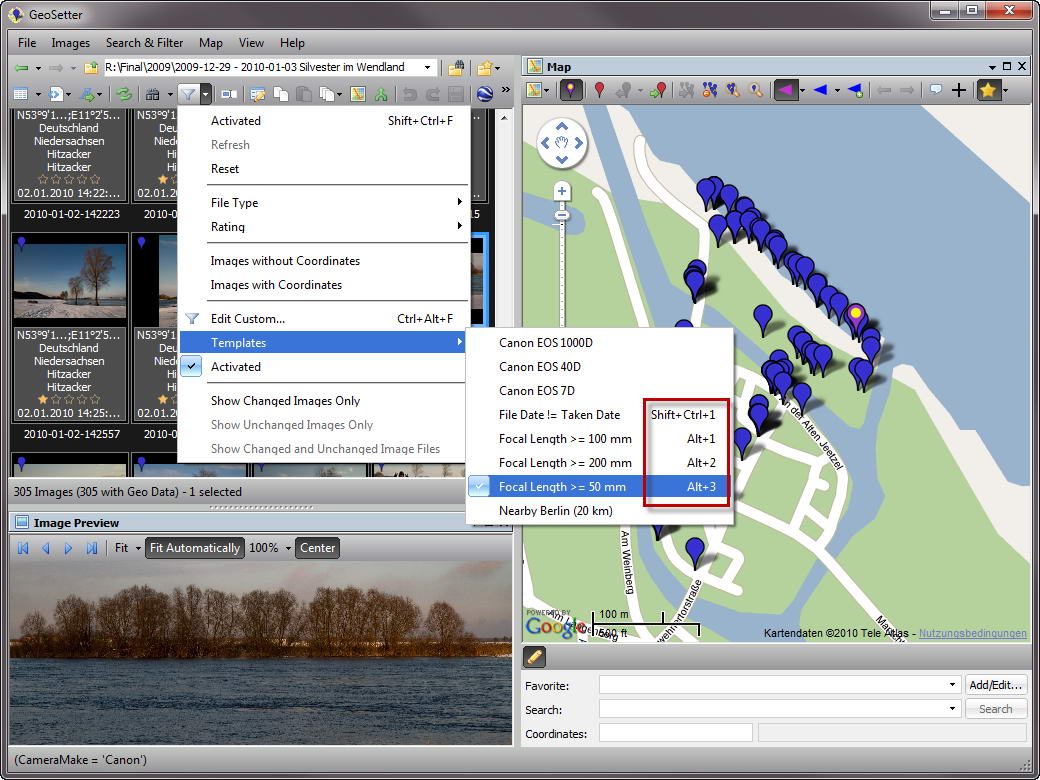
+ Assigning keyboard shortcuts to search-/filter templates
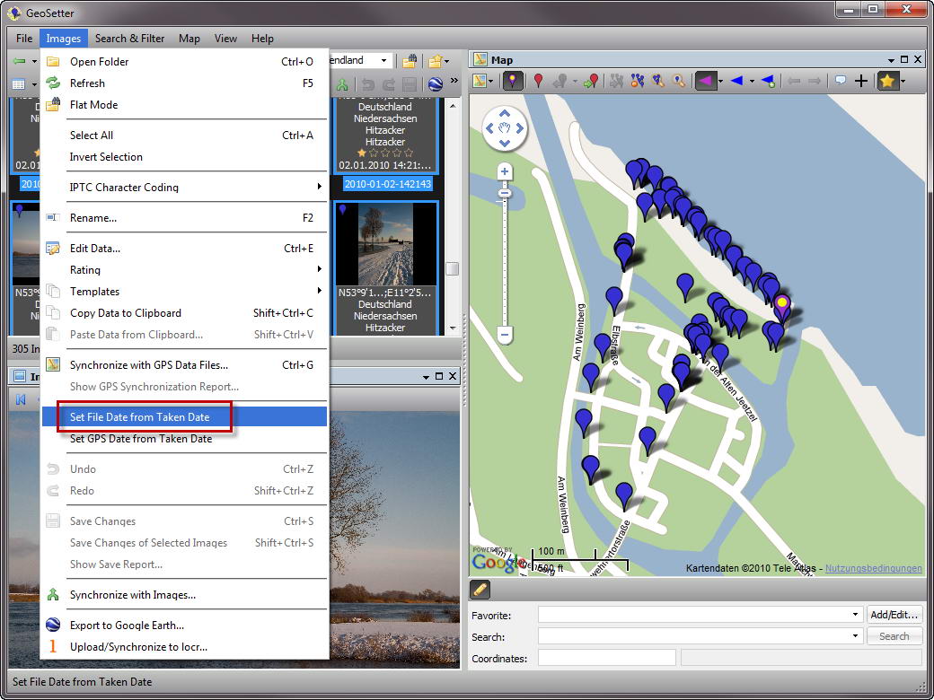
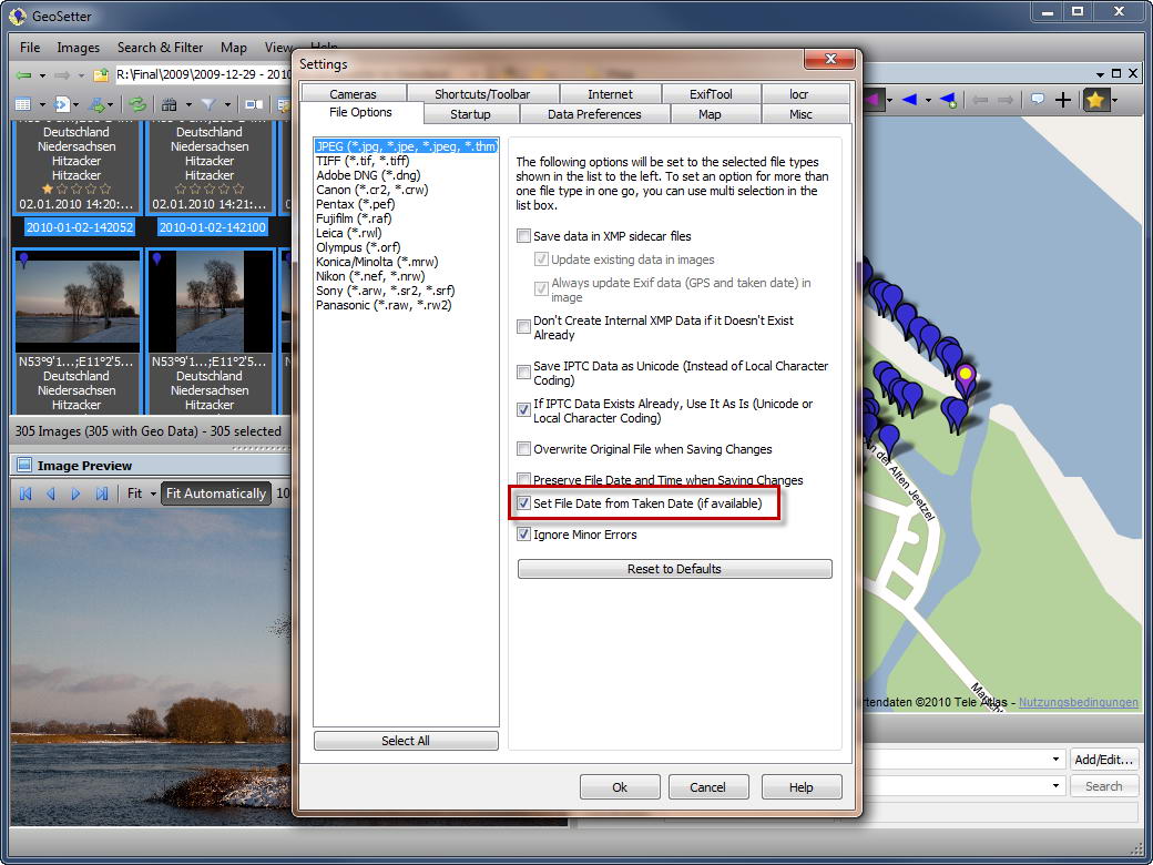
+ Filetype option for setting file date to taken date when saving image data
+ Setting file date from taken date for selected image files
! Track files with lots of waypoints (>1.000) have been shown very slowly
! Problem with special library folders under Windows 7Some other small changes, improvements and fixes
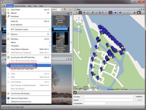
Setting File Date from Taken Date for Selected Image Files 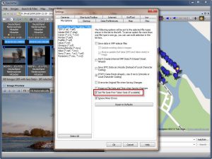
Filetype Option for Setting File Date to Taken Date when Saving Image Data 
Selecting Search/Filter Templates by Using Keyboard Shortcuts 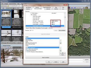
Assigning Keyboard Shortcuts to Search-/Filter Templates 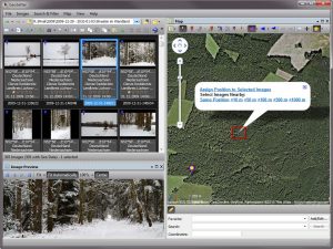
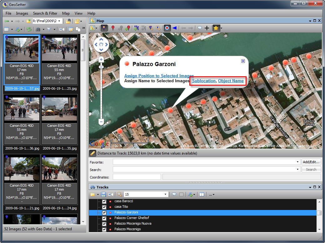
Right Click on Map for Assigning Image Positions and Selecting Nearby Images 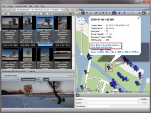
Right Click on Blue Image Markers for Assigning/Copying Image Data - Update 3.3.32 2010/03/05
! The rename function caused sometimes the image files to be renamed to a new name without file extension
- Update 3.3.30 2010/03/03
* Some minor changes regarding assigning image direction in map
! Map panel can not me moved after undocking from main windowSome other small changes, improvements and fixes
- Update 3.3.18 2010/02/21
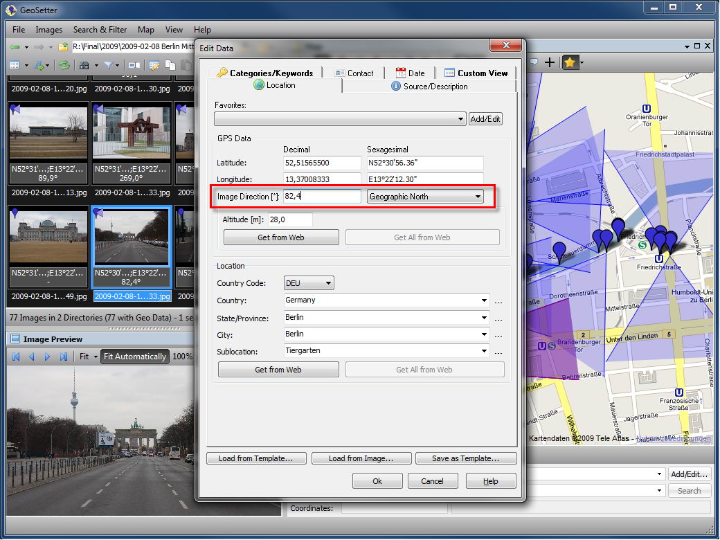
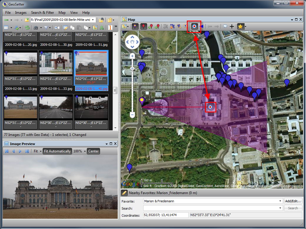
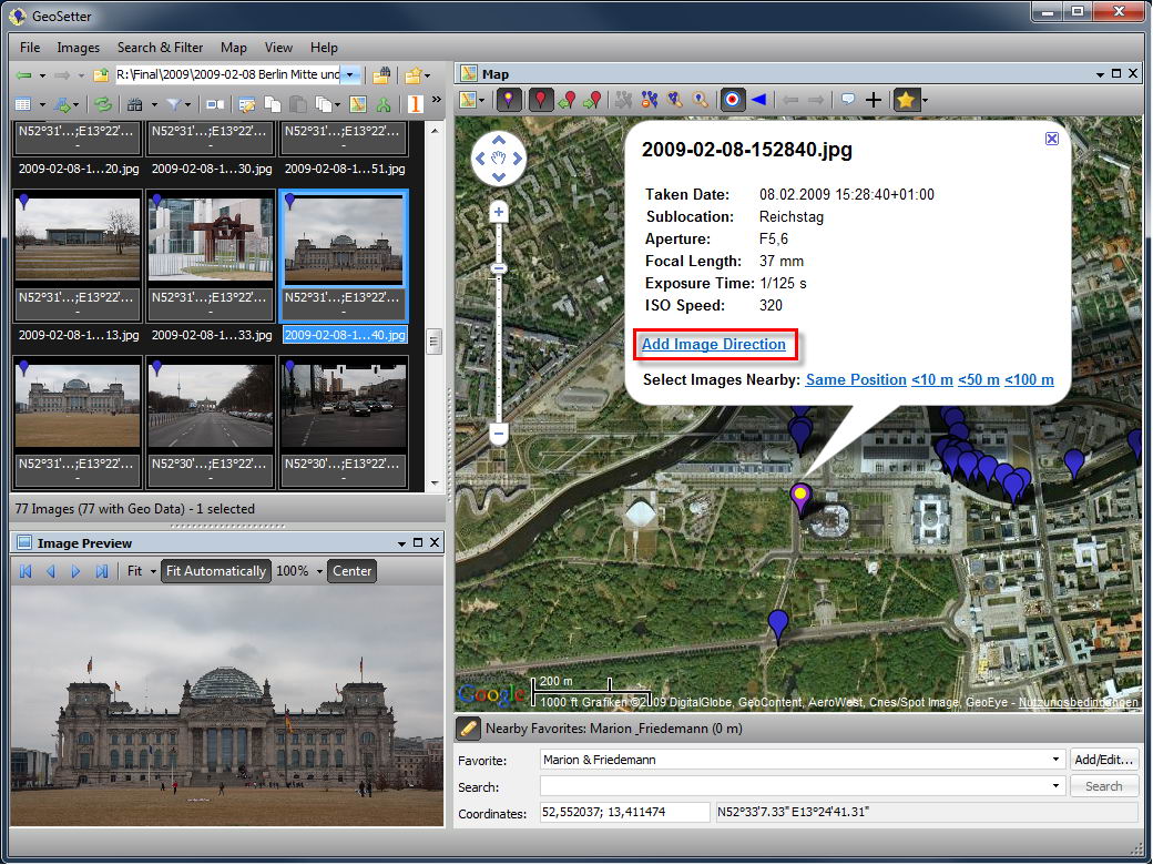
+ Some changes regarding adding and modifying image directions (new toolbar button and menu option for adding image direction and possibility to add/modify image direction by dragging image markers on the map)
+ Optimized display of image direction of focused image (auto adjust size to map)
+ Point of view coordinates now editable in dialog
+ Faces will now be read also from Google Picasa. Renaming image files in GeoSetter will adjust Picasa database and therefore keep face assignments in touch.
+ Consideration of Apple iPhone regarding focal length and 35mm equivalent focal lengthSome other small changes, improvements and fixes
- Update 3.3.10 2010/02/16
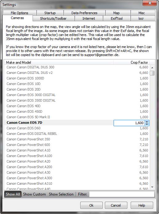
+ Editor for camera crop factors for calculation of 35mm equivalent focal length and therefore correct display of view angles on the map
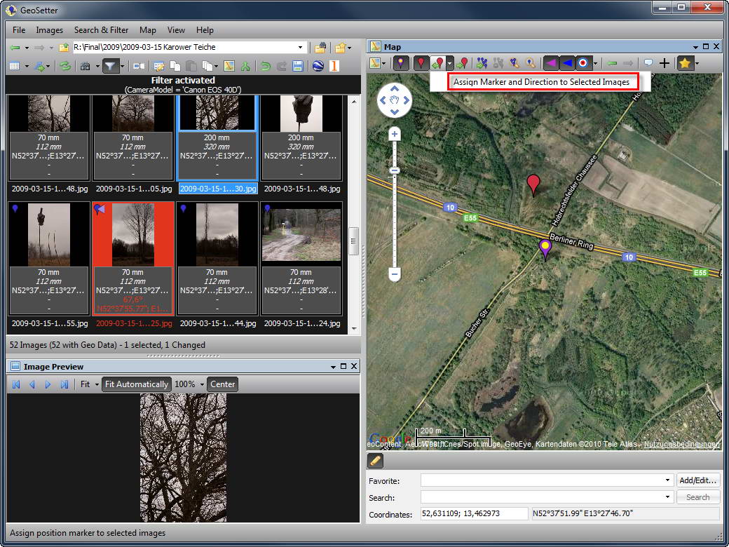
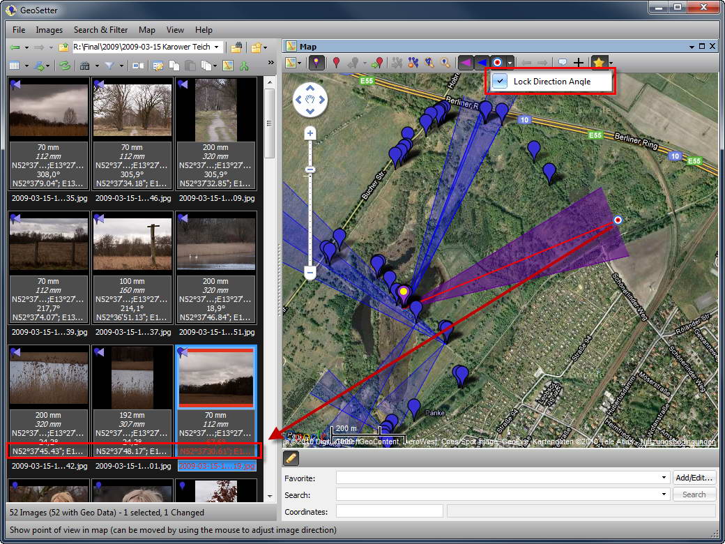
+ Setting and saving view point (with optional locking of image direction)
+ Assigning map position and image direction in one step
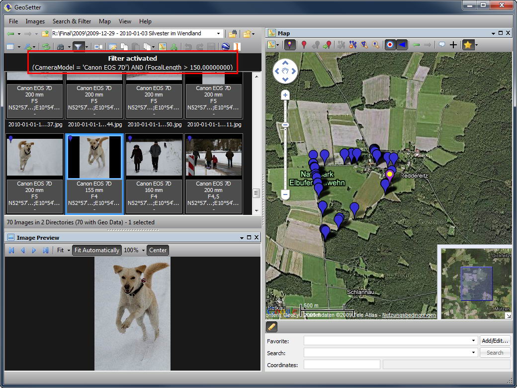
+ New filter options
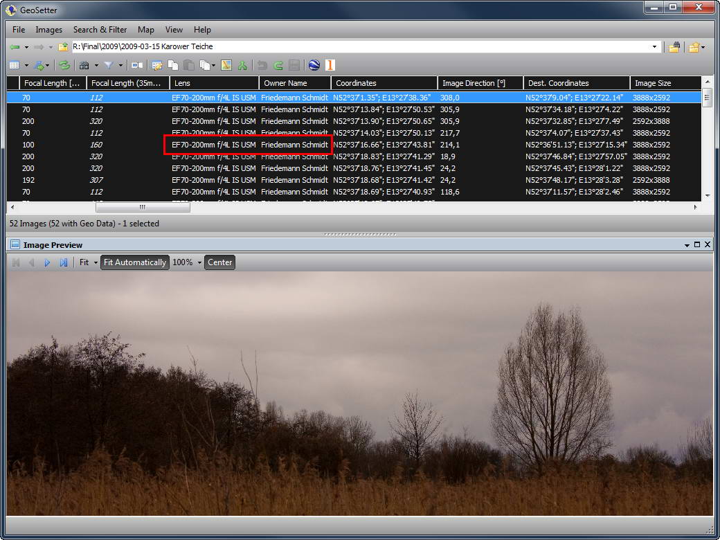
+ Showing lens and camera owner name
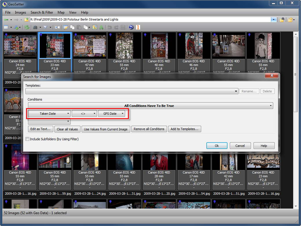
+ Comparing dates in search and filter
+ Saving data of selected images
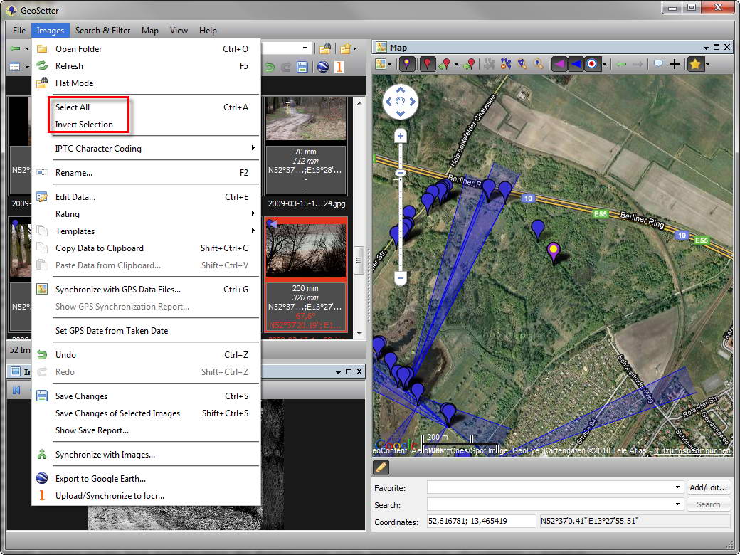
+ Select all / invert selection
+ Set GPS date from taken date
! Keyboard shortcuts did not work with focused map
! Face tags written by Microsoft Live Photo Gallery have not been recognized
! Date of GPS date has not been readSome other small changes and improvements

Set GPS Date from Taken Date 
Select All / Invert Selection 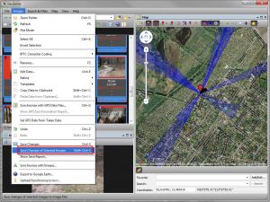
Saving Data of Selected Images 
Comparing Dates in Search/Filter 
Showing Lens and Camera Owner 
Additional Filter Options 
Assigning Map Position and Image Direction in One Step 
Setting View Point with Optional Locking of Image Direction 
Crop Factors for Calculation of 35mm Focal Length - Update 3.3.1 2010/02/03
+ Option to hide/show direction marker in map of focused image
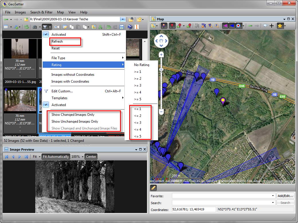
! Fixed some minor problems with filter (for changed image files the filter will not be applied immediately, instead they will be filtered after save or by using new option “Update On Changed Files”)
! Window layouts has not been restored by using “File | Restore Settings…”
! Fixed problem with timezone Europe/London (daylight saving time has not been calculated)
! Hopefully fixed ExifTool problem regarding “Error renaming temporary file to…” - Update 3.3.0 2010/01/31
+ Editing and showing image directions
+ Show/hide overview map
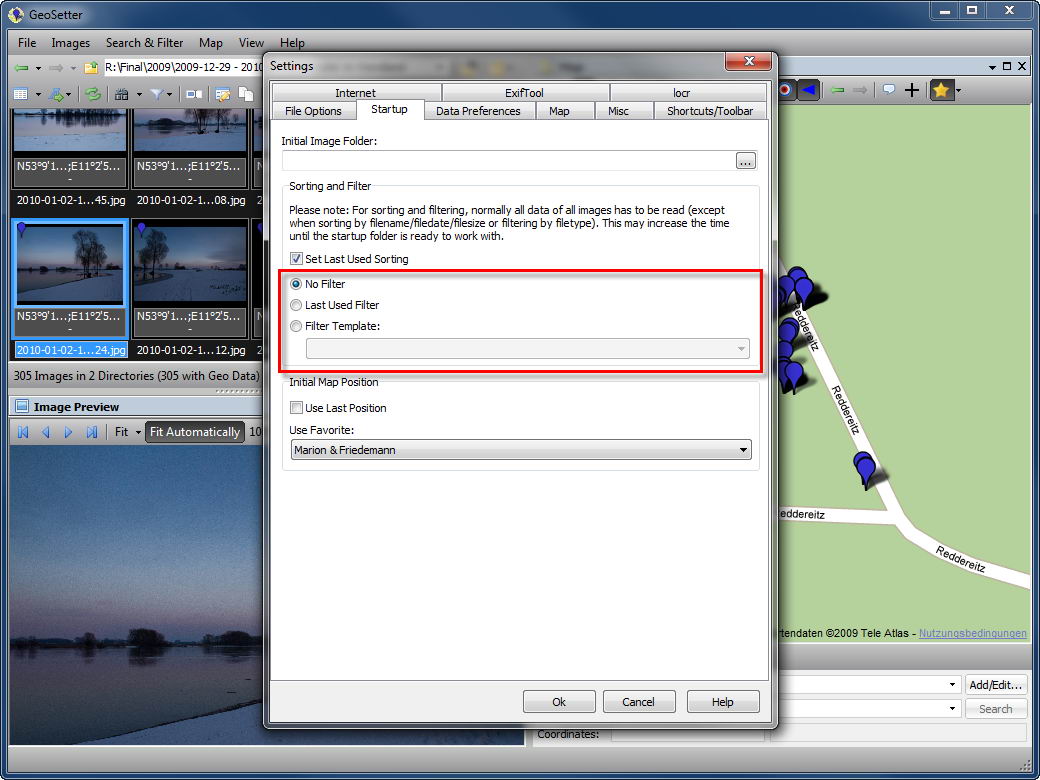
+ Filter setting for startup
+ Enable/disable custom filter
+ Filter info
+ Show faces (identified by Google Picasa or Windows Live Photo Gallery)
+ Assign waypoints names
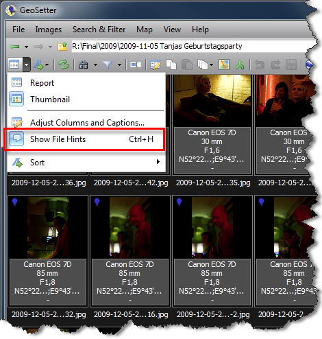
+ Activate/deactivate file hints
! Sometimes excpetion when tagging THM filesSome other small changes and improvements

Activate/Deactivate File Hints 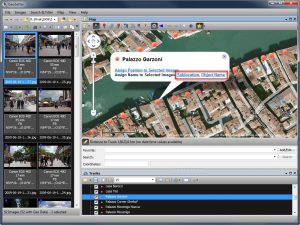
Assign Waypoints Names 
Show Faces (Identified by Google Picasa or Windows Live Photo Gallery) 
Filter Info 
Enable/Disable Custom Filter 
Filter Setting for Startup 
Show/Hide Overview Map 
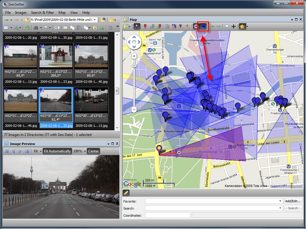
Edit Image Direction 
Show Image Directions on Map 
Change Image Direction in Map 
Add Image Direction in Map - Update 3.2.6 2010/01/13
+ Save last used filter and optional restore on startup
+ New register “Startup” in settings dialog
! Show ExifTool updates only when Windows version available
! Help pages have not been found - Update 3.2.5 2010/01/10
! Changes may be saved also to RAW files when option was enabled to save only XMP sidecar files
! Buttons disappeard in dialogs on Vista and Windows 7 when pressing ALT key
! Filter/search condition did not work with OR on filenames
! Sometimes exception in Edit Data dialog (“Cannot focus a disabled or invisible window.”)Some additional minor fixes on the user interface.
- Update 3.2.3 2010/01/07
! Crash on startup on some system configurations
- Update 3.2.1 2010/01/06
! Data of image files has not been read when image file was located in a folder containing Asian characters.
- Update 3.2.0 2010/01/06
+ Supports multiprocessing when saving image data
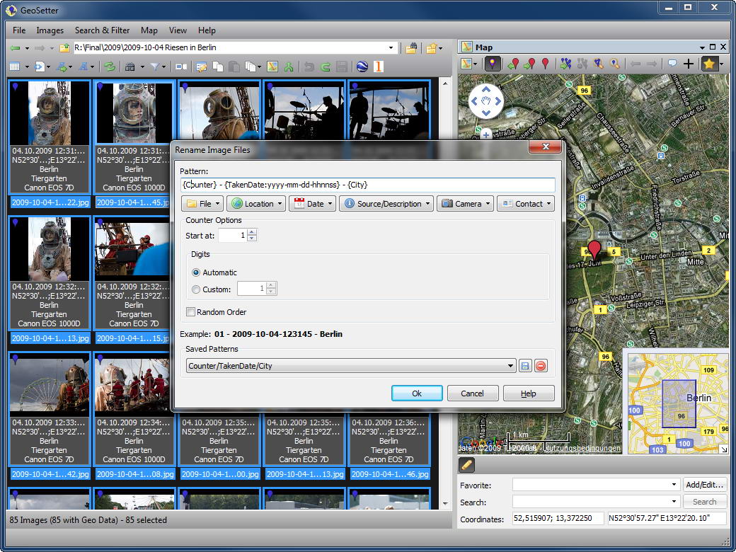
+ Functionalety for renaming image files
+ Copy and paste of meta data
+ Option to show imperial measurement units
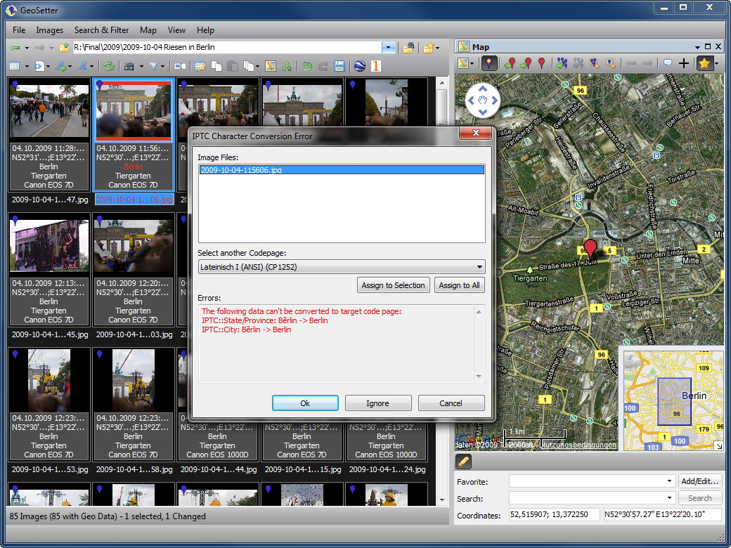
+ Selection of IPTC character coding
+ Customizing toolbar
+ Shortcuts for menu commands
+ Save and restore of program settings
+ Edit and assign data templates
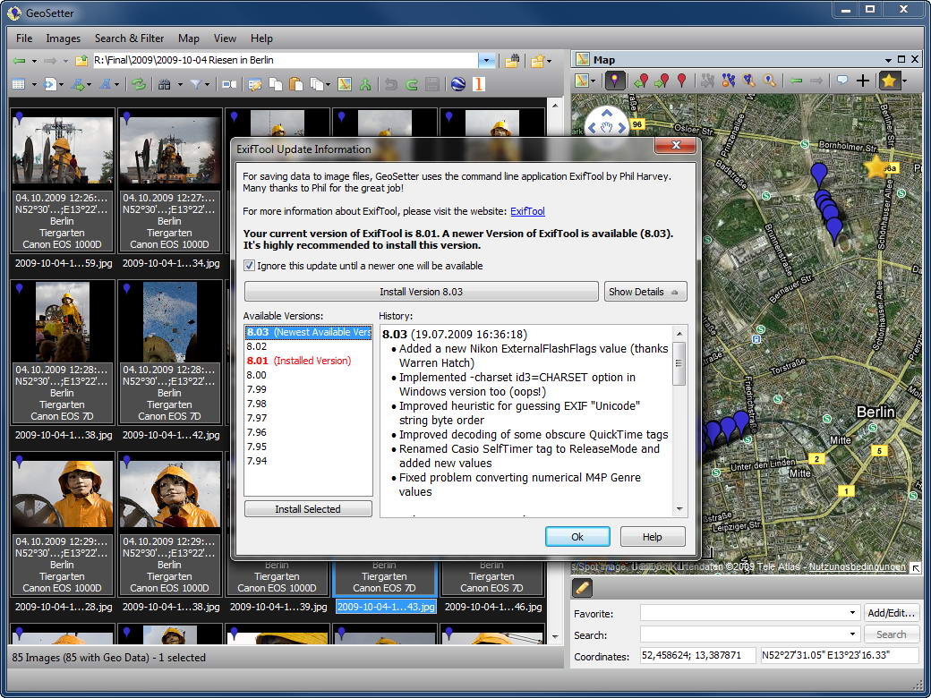
+ ExifTool update info
+ Support for MTK GPS loggers by using GPSBabel (iBlue 747 etc.)
+ Support for Holux GPS logers by using GPSBabel
+ Adjustable startup folder
+ Image preview in tooltips
+ Optional use of remote images for Google Earth export
+ Display of track length and track point distance in track panel
+ Selection of images by using reference image on map
+ Custom image title for Google Earth export
+ Support for THM files
* Exclude KMZ files from automatic display of tracks in current folder
! Wrong sorting of images
! Problems with Explorer shell extension
! Timezone has been overwritten sometimes while saving changes
! Writing GPS tag exif:GPSVersionID
! Problem with some GPX files
! Problem with some KML filesMany other small changes and improvements

Preview in Tooltip 
Tooltip Options 
Filter for Metadata 
IPTC Coding Selection (1) 
IPTC Coding Selection (2) 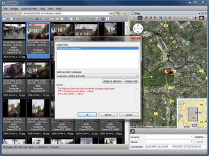
Error Message regarding IPTC Coding 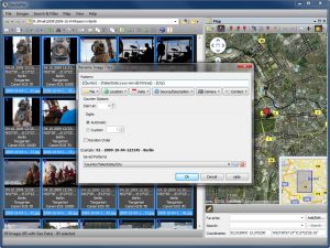
Rename Image Files (1) 
Rename Image Files (2) 
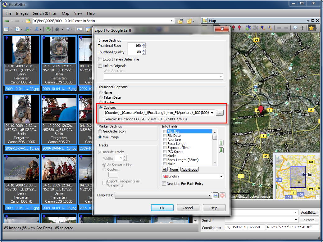
Custom Image Caption for GE-Export 
Select Data Template 
Edit Data Templates 
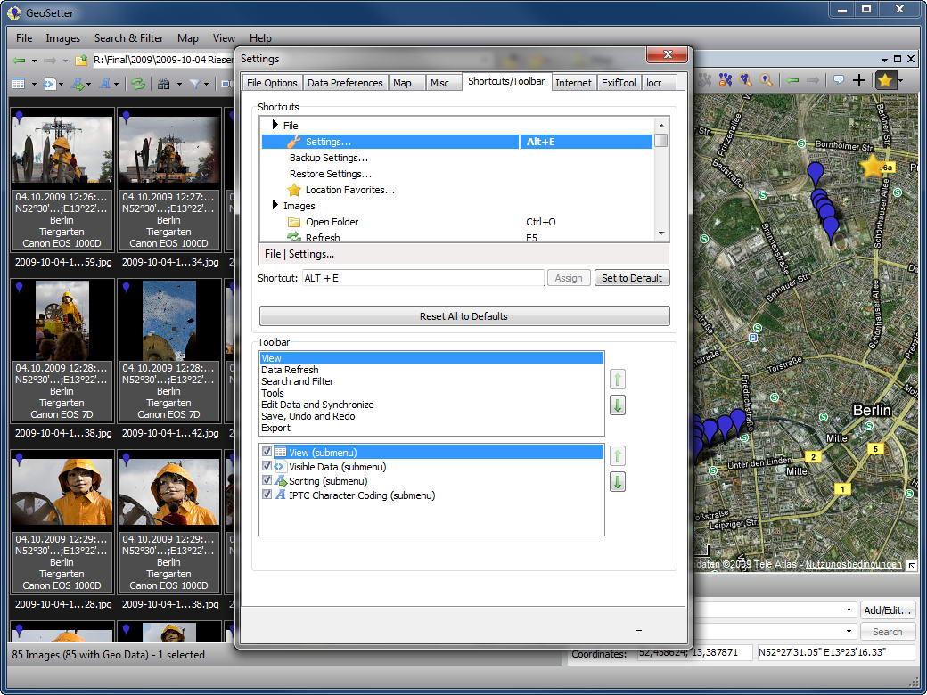
Keyboard Shortcuts / Customizing Toolbar 
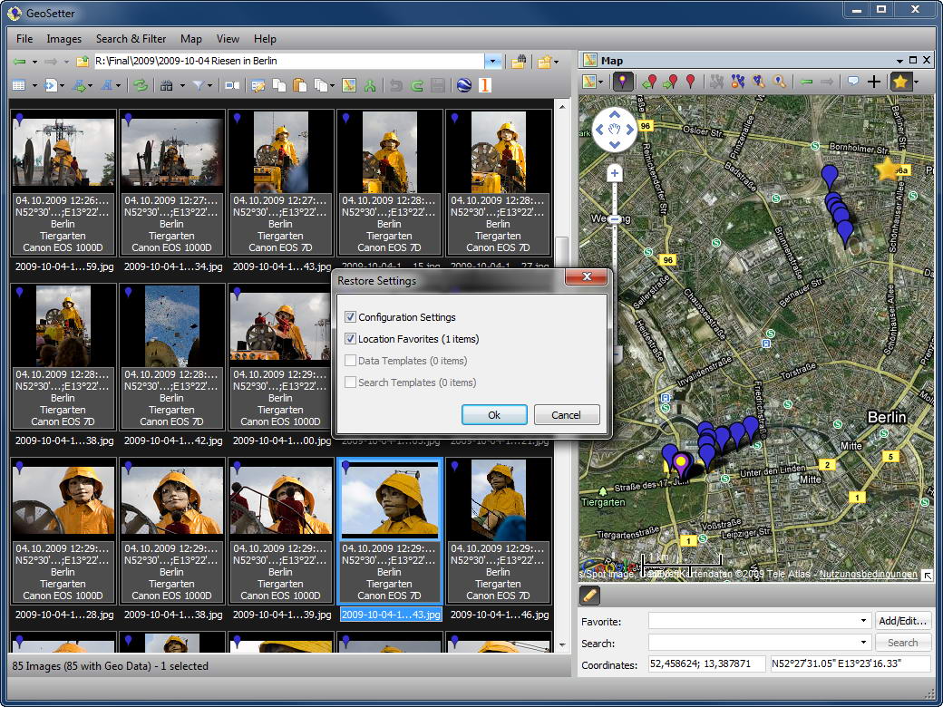
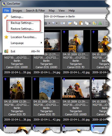
Restore Settings 
Backup/Restore Settings 
ExifTool Update Info 
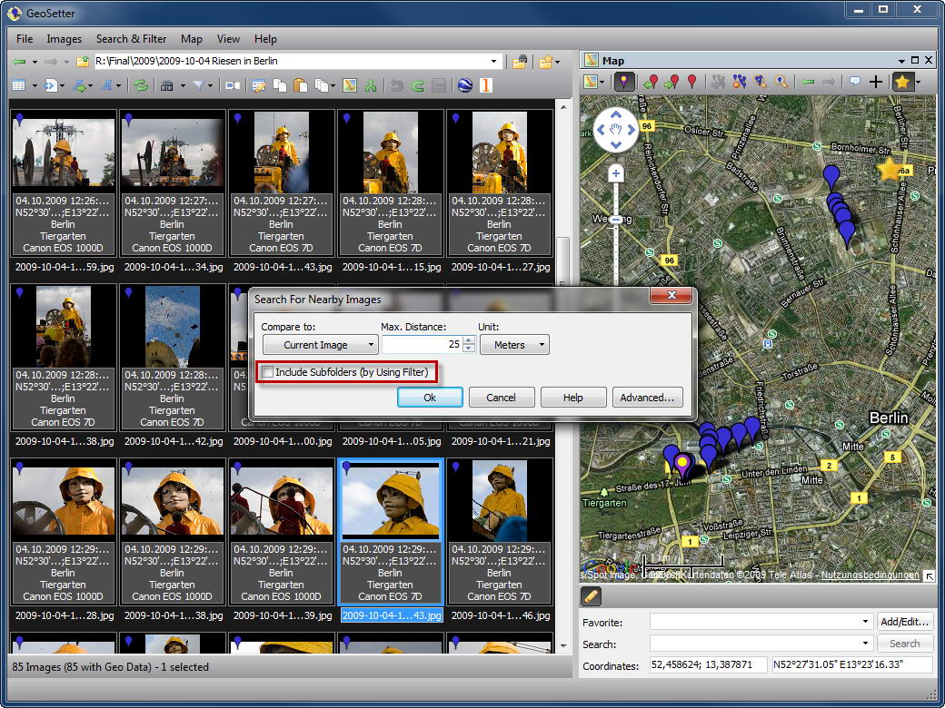
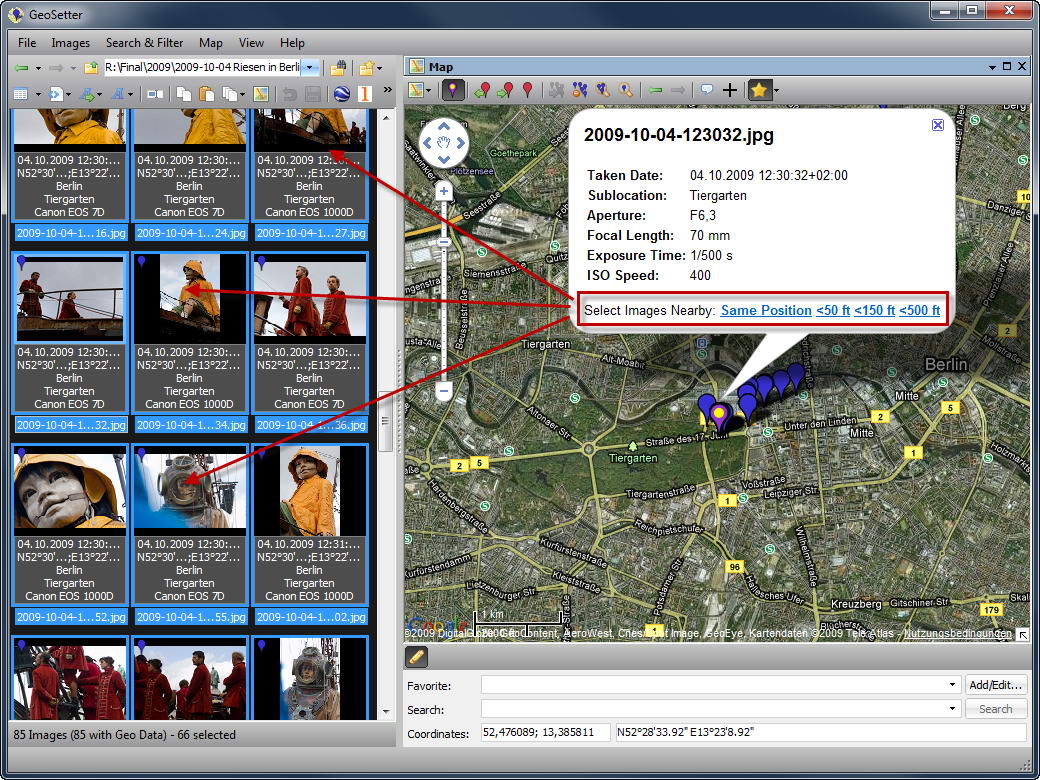
Nearby Image Search 
Image Search 
Select Images by using Map 
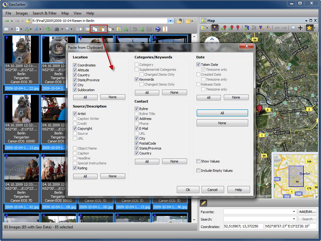
Copy/Paste Metadata - Update 3.1.20 2009/08/18
! ExifTool could corrupt Nikon NRW files
! Renaming file in GeoSetter doesn’t rename sidecar file
! GPX not valid with specific description data
! Problems with support for Exif Artist
+ Support for CoPilot track files - Update 3.1.16 2009/07/29
+ Support for OziExplorerCE waypoint files
+ Support for Garmin MapSource track files
+ Support for Canon THM files
+ Support for changing Exif artist
+ Updated version of ExifTool to support DNG 1.3
+ Option to reset filter
! Wrong display of GPS time
! Canon CRW files contain no date time value
! Crash in settings dialog on some Chinese systems
! Local characters will be garbaged sometimes when exporting to Google Earth
! Cannot read GPX way points file
! Automatic assignment of location data doesn’t work
! Error when reading GPX files with XML version=”1.1″
! Wrong display of GPS Speed Values
! Some problems regarding filter functionalety
! Exported kmz-Files will not open in GoogleEarth
! Sometimes crash with Panasonic RAW files
! Changing coding for IPTC values have to force rewriting of complete IPTC data
! Wrong orientation in Lightroom after initially creating XMP of ARW filesSeveral minor bug fixes
- Update 3.1.5 2009/06/01
! Preview of ARW files displays in very low resolution
! Sometimes changes can’t be saved
! Ratings won’t be read sometimes
! Strange progressbar behaviour when uploading to locr
! Some RAW files will be exported in wrong orientation to Google Earth and locr
! Cannot modify timezone value
! Wrong Time Zone for Athen - Update 3.1.3 2009/05/25
! Caching of already requested GeoNames data
- Update 3.1.2 2009/05/24
! Favorites don’t show hint window in map
! Folder favorites not visible in toolbar - Update 3.1.0 2009/05/24
+ Support for Panasonic RW2 and RAW files
+ Support for Leica RWL files
+ Support for Nikon NRW files
+ Support IGC (International Gliding Commission) track files
+ Added Open Street Map to map view
+ Rating editable in report and list view
+ Option to add country code automatically to keywords
+ Language support for info panel
+ Support speed values read from GPX files
+ Optional map will show last map position on startup
+ Support for commercial GeoNames account
+ Caching of already requested GeoNames data
+ Improved performance on reading image files
+ Order of saved screen layouts can be changed now
* When adding XMP data to image initially, all existing data from Exif and IPTC will be synchronized
! Several problems regarding language specific character sets (filenames and IPTC data). Many many thanks to Atsushi Murai!!!
! Several problems regarding export to Google Earth
! GeoSetter hangs up on specific NEF files on Vista 64
! Network drives not shown in open folder dialog
! Source URL not saved to /loaded from template
! Case insensitivity in keywords
! Sometimes altitude values will be read not correctly
! Copyright in Exif can’t be removed
! Synchronizing with other images didn’t synchronize ratings
! Waypoints won’t be shown correctly
! Screen layout shortcut keys are shifted when new layout is added
! Renaming of files didn’t work
! Editing sexagesimal coordinates changed South to North - Update 3.0.14 2009/02/11
* Updated to ExifTool 7.67
- Update 3.0.4 2008/08/21
! Wrong behaviour with file type filters when changing folders
! It was only possible to save changes to XMP sidecar files for TIFF files - Update 3.0.3 2008/08/19
! Bug in search and filter conditions
! Wrong button positions in some dialogs - Update 3.0.2 2008/08/13
! The shell extension for showing GeoSetter menu entries in the Explorer context menu was not included in 3.0.1
! Problem with opening KML/KMZ track files
! Problem with ExifTool version 7.39. Switched back to 7.37 - Update 3.0.1 2008/08/10
! Division by zero with some track files containing more than one position at the same time
- Update 3.0.0 2008/08/10
+ Floating and dockable windows
+ Customizable filter and search criteria
+ Showing image files from subfolders (flat mode)
+ Upload and synchronization with locr.com
+ Showing currently focused image as seperate marker in map
+ Additional options for export to Google Earth
+ Support for dBase shape format (ESRI) track files
! Exception when exporting to Google Earth with user names containing non ASCII characters
! Dialogs sometimes too large for some screen resolutions
! Problem with time zonesMany additional minor changes and bug fixes.
- Update 2.5.2 2008/05/18
+ New option in GPS synchronization dialog by using synchronization time offset after selecting a trackpoint and a reference image
+ New option in GPS synchronization dialog for synchronizing with all track files in current directory
+ Renaming of track files
+ Reading *.nma track files
* Ignoring invalid track points in NMEA track files
! Save button was sometimes deactivated when using file filter
! Fixed problem with GeoSetter ShellExtension and Windows XP SP2 - Update 2.5.1 2008/05/12
+ Online help (still under construction, many thanks to Heiko Leupolz)
+ Support for Sony Raw files (ARW, SR2 and SRF)
+ Shell context menu for Windows Eplorer
+ Command line parameters
+ Improved handling of map position favorites
+ Display of track points
+ Changed handling regarding time zones. Time zones are now mandatory in date values
+ Optional export of track points to waypoints in Google Earth export
+ Optional export of image date time values to Google Earth
+ Mini images in map when exporting to Google Earth
+ New option to copy EXIF original date time to other EXIF date time fields
+ Photo markers are now draggable in the map
+ Import for Google Earth KML and KMZ track files
+ Import of Garmin TCX and GiSTEQ Phototrackr track files
+ Editable hint data for image markers in map
+ Filter for images with or without coordinates
* Improved dialog for GPS synchronization. Daylight saving time is not used anymore because it’s included in the time zone
* Improved acceptance for manual input of coordinates
* Improved performance for reading large track files
* Improved online requests for location data
! Wrong display of camera correction in GPS synchronization dialog
! Sometime wrong layout of dialogs with large system fontsMany additional minor changes and bug fixes.
- Update 2.4.3 2008/03/12
! NMEA files with $GPGLL and $GPZDA data hasn’t been read
! Wrong display format for exposure time - Update 2.4.2 2008/03/11
! Sometimes wrong GPS synchronization when using more than one track file
- Udpate 2.4.1 2008/03/05
! Folders with archive option and network drives haven’t been shown
! Minor bug fixes - Update 2.4.0 2008/03/01
+ Improved dialog for synchronization with GPS files
+ GPS synchronization report
+ Improved track functionalety (improved presentation in tree view, waypoints, possibility to split tracks automatically when exceeding distance or time between two track coordinates etc.)
+ Proxy settings
* Updated French translation (many thanks to Arnaud Mouronval)
! Improved recognition of time zones and daylight saving time for GPS synchronization
! Several minor bug fixes - Udpate 2.3.0 2008/01/23
+ File options can be specified for each file type seperately now
+ Support of Magellan track files
+ Caching GPX track files for faster reuse
+ Unicode support for IPTC
+ Adding location data automatically to keywords
+ Copying taken date to IPTC creation date automatically
+ Norwegian translation
! Values for time shifting in GPS synchronization had been added always, regardless the user’s choice of substraction
! If a GPX file contains more than one track, GeoSetter has handled it as one track
! No caption display on registers in data dialog with Windows 64 bit (XP and Vista)
! Sometimes portrait format images has been shown stretched after Google Earth export
! Several minor bug fixes - Udpate 2.2.5 2008/01/07
+ Improved GPS synchronization
+ Possibility to edit online requested location data directly
+ New translations (Danish and Dutch)
* Deactivated automatic removal of directory favorites
* Optimized data dialog
! Error when writing IPTC/XMP data containing quotes
! Exception when selecting no time zone in GPS synchronization dialog
! Ctrl+A now selects only image files
! Pressing RETURN in empty keyword list caused excpetion
! Data synchronization between images didn’t consider time zone
! Wrong interpretation of coordinate values encoded by degrees, minutes and seconds
! Improved performance when selecting a lot of images – e.g. by pressing Ctrl+A
! Sometimes wrong behaviour when showing tracks - Update 2.2.4 2007/12/29
Please note: For synchronisation with GPS tracks, now the time zone of taken date will be used if available in the image. If the results of synchronisation aren’t as expected, please check the time zone of your images (dialog “Images | Edit Data…”).
+ Optional online request for taken date time zone when assigning coordinates
! Exception when saving/selecting column layout templates
! Non existing time zone has been saved as “+00:00″
! Wrong track colours in Google Earth export - Udpate 2.2.3 2007/12/21
+ Added timeout for online request regarding location info and altitude value
+ Possibility to open more than one track by using multiselection in open track dialog
+ Possibility to show tracks which don’t include date time information
+ New options for online requests of location infos and altitude values when assigning coordinates from map
! When synchronizing with track folders, sometimes the wrong tracks had been shown on the map
! The option “Overwrite original images” and “Preserve date time” didn’t work in some situations
! Other minor bugfixes - Udpate 2.2.0 2007/12/15
+ Unicode support for metadata (XMP)
+ New window for showing all meta data
Additional changes at the user interface and other bugfixes - Udpate 2.2.1 2007/12/15
! Exception when sorting by text columns
! Ok button in data dialog - Update 2.1.0 2007/12/09
+ Automatic synchronization between EXIF/IPTC and XMP data when saving
+ Support for XMP sidecar files
+ Support for timezone of taken date
+ Support for Google Maps terrain map
+ Support for Flickr geodata in keywords
+ New Spanish translation
* New designed data dialog
! Some data hasn’t been copied when copying data in data dialog
! Excpetion when reading some GPS data
! Images taken in portrait format sometimes has been exported to Google Earth in lansdcape mode
! Problems with language specific characters in filenames regarding Google Earth export
! Excpetion when hiding visible tracksAdditional changes at the user interface and other bugfixes
- Udpate 2.0.1 2007/11/23
! Problem with missing msxml4.dll on some systems (now msxml3.dll will be used)
! IPTC data of some images hasn’t been recognized
! Sony track files hasn’t been recognized automatically as directory tracks - Udpate 2.0.0 2007/11/22
+ Showing tracks
+ Editable IPTC data (IPTC-NAA/XMP)
+ Google Earth export
+ Fetching altitude values by using a webservice
+ Support for JPE-, JPEG- and RAF-files
+ Support for Sony track files
+ Interpolation for track synchronization
+ Optional parameters for ExifTool
+ File filters
+ Online update of translation files
+ New translations (Italian, Swedish, Czech)
+ Saving configuration now in config files instead of Windows registry
* Improved display of ORFs and NEFs
! Bug in browse history
! Bug in reading Internet Explorer proxy settings
! Sometimes wrong reading of altitude values from NMEA files
! Scrolling behaviour of image browser and map
Additional changes at the user interface and other bugfixes - Update 1.3.0 2007/10/21
! NMEA files of some GPS devices haven’t been recognized
+ Translation to French language (many thanks to Pixel_K)
+ New preview image in dialog for selection of IPTC location info
+ Fixed bug in NMEA files of TimeMachine X (Software for Wintec GPS devices)
* When setting GPS position of images manually, the GPS date will be set to shooting date (if available) instead of current date
* Some changes on user interface - Update 1.2.2 2007/10/16
! Before editing the location for an image by using the dialog, the image data has been refreshed from image file. Changes to the image data which has been done perhaps before, has been discarded
! Reading of IPTC location infos failed on some images
! When sorting in descending order, directories has been arranged to the end - Update 1.2.1 2007/10/14
+ Minolta RAW files (MRW) included
+ Filling IPTC location fields (country, state/province, city etc.) automatically
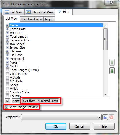
+ Adjustable columns, thumbnails and hints
+ Translation to Russian language (many thanks to Andrey Ilyin)And a lot of changes at the user interface, minor bug fixes and more…
- Update 1.0.1 2007/09/23
! Application freezed because of corrupted Olympus maker notes